Ancient Nottingham: The oldest streets that shaped our city


Nottingham is a city of twos. Two universities. Two major hospitals. Two renowned football clubs. Two rivers.
And this duality is an echo of an ancient division. A thousand years ago there were in effect two Nottinghams: two towns, two cultures, two distinct communities living in an uneasy apposition. Even the ancient market square was pared into two by a dividing wall.
Advertisement
Hide AdAdvertisement
Hide AdThere were two Nottinghams because, in effect, there were two Englands. There was the nation of the Anglo-Saxons, who, five centuries after arriving on our shores, had established dominion over the whole of formerly Roman England.
Read more: Your Nottingham
Within that realm lay the town of Nottingham, formerly Snotta inga ham - Anglo-Saxon for the village belonging to Snotta, the presumed founder - then Snottingham, then, Nottingham.
That first settlement, some time in the 6th century, existed entirely on the hilltop above the sandstone cliffs and caves of Hollowstone to the east and the broad River Leen marshes to the south.
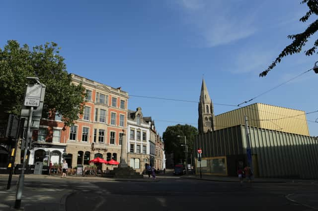
Today, we call it the Lace Market. From that humble conception the village became a town, or ‘burh’ - a fortified settlement - and Nottingham’s early history began to unfold.
Advertisement
Hide AdAdvertisement
Hide AdThen came the French Normans. And in one bloody battle, England fell.
King William the Conqueror
After 1066 the kingdom of England may have been the domain of the Normans, but the peoples of the island were still then predominantly Anglo-Saxon English. An uneasy cohabitation emerged, across the country, and within many of its counties and towns.
There can be fewer more revealing pictures of this than in Nottingham where, having established control of the town, the Norman King William the Conqueror ordered one of dozens of new fortifications around England.
The site he chose was a high rocky peak overlooking the town, and the River Trent off in the distance. Today, we call it the Castle Rock.
Advertisement
Hide AdAdvertisement
Hide AdAnd where the Norman king laid down his castle, the new Norman population, the uneasy new arrivals, chose to reside. The result was a divided town and two distinct boroughs: to the west, the French, to the east, the Anglo-Saxons, still on the site settled by their ancestors some 600 years before.
To understand this history is to understand Nottingham’s ancient geography, and its oldest streets.
For starters, the original town, we know from discoveries of Anglo-Saxon defensive ditches, was confined to the Lace Market area.
And thanks to the work of Nottingham historian Andrew Nicholson of the Thoroton Society, and a map he has produced showing what the town would have looked like circa 1500, we can see how those first street names had by then mingled with old French names.
Advertisement
Hide AdAdvertisement
Hide AdThe communities were merging and the new town was taking shape.
What did Nottingham look like?
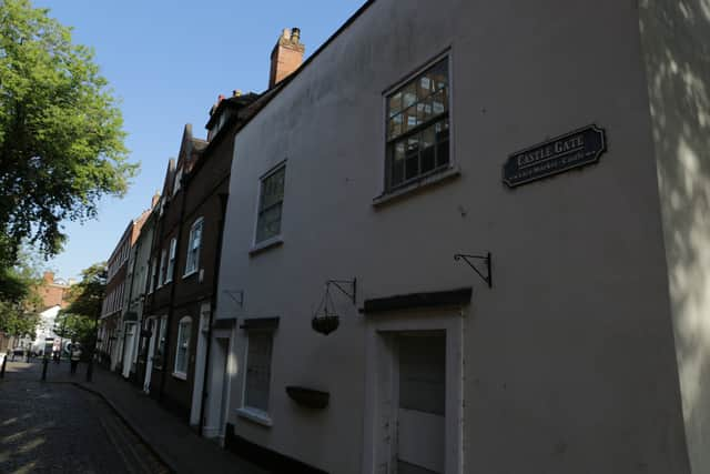
So, running around the Anglo-Saxon settlement were the streets of Warser Gate, Bellar Gate and Fletcher Gate - the word ‘gate’ not, in fact, meaning an entrance, but deriving from the Old Norse word ‘gata’, meaning road. By 1500 these early roads had already begun to be weaved through by others bearing French-derived names: High Pavement for one.
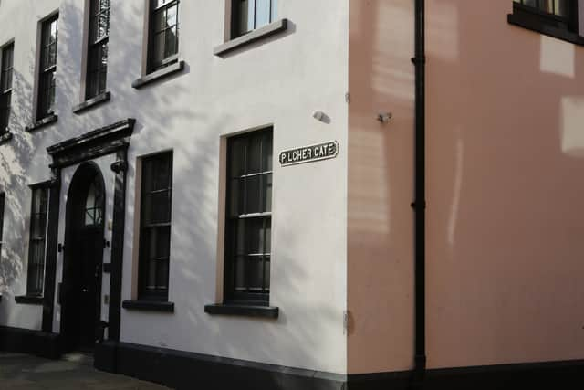
The 1500 map reveals numerous ‘gates’ around the city, each signifying the type of labour or trade that went on there. Some are pretty obvious - Castle Gate and Bridlesmith Gate, for example, the latter being the street of the equestrian craftsmen for centuries - while others are a bit more mysterious.
There is some debate as to whether Fletcher Gate is a reference to the old (and modern) English word ‘flesh’, and the many butchers or ‘flesh hewers’ that worked there. Or it may be because it was also at times the area where arrow makers could be found - the word fletcher stems from the Anglo-Norman word for feather, fleche. Pilcher Gate was the site of ancient ‘pilchers’, or fur makers. Tanners, working with leather, used tannin derived from oak bark - a fact inscribed into Nottingham history to this day, in the name of Barker Gate.
Advertisement
Hide AdAdvertisement
Hide AdOne of the earliest original maps of Nottingham is the plan of the city’s streets made by cartographer John Speed in 1610. With the ornate title of The countie of Nottingham described: the shire townes situation and the earls there of observed, Speed’s chart shows some of the very first streets - which still exist today - and those to have been established by the early 17th century.
Many names on original map still in use
Among those new names are many still in use, and others to have disappeared from the map. That may be for the best in the case of Bearward Lane - had it not been renamed as Mount Street in 1810, we would daily be reminded of the brutal bear-baiting that went on there in the medieval period.
Another street still bearing its ancient name is Greyfriar Gate, now a blink-and-you-miss-it link between Maid Marian Way and Carlton Street, running down the south side of the derelict former Broadmarsh Centre site. In the 13th century that site of the future shopping centre is marked as ‘Graye Friers’, in reference to the Franciscan friary that once stood there.
The modern Friar Lane led to another friary, the Whitefriars, also dating to the 13th century.
Advertisement
Hide AdAdvertisement
Hide AdTo the north there are echoes of the town that had emerged by the end of the 15th century, after expansion by the Normans extended the town’s boundaries. One of the most revealing of these appears on the map of 1500 and still stands today.
Next time you pass through Chapel Bar, at the far end of the Old Market Square, make a note of the fact you’re passing through what was once one of the ancient gateways to the town, which was otherwise surrounded by a new defensive wall.
Another gate through the medieval walls, Cow Lane Bar, long since lost, was positioned at the junction of the modern Mansfield Road and Parliament Street.
The walls have long since fallen and the city has grown, but there are echoes of the past everywhere we walk, in the streets we pass over every day.
Editors note: The picture at the top of this article has kindly been supplied by Andy Nicholson, Nottinghamshire History website www.nottshistory.org.uk.